Water Infrastructure Beyond Borders
Paola Aguirre | Master in Architecture and Urban Design
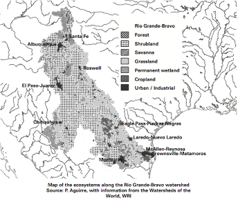
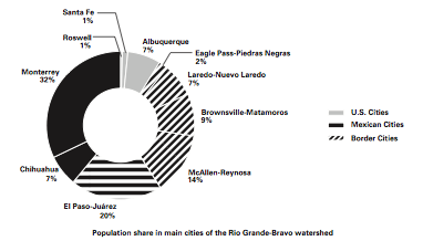
The Rio Grande-Bravo1 is the most significant watershed shared by the United States and Mexico, covering nearly 500,000 square kilometres across seven states, its watercourses touching ten major cities of between 50,000 and four million inhabitants. This watershed connects Santa Fe, New Mexico to Monterrey, Nuevo León. These two are hardly sister border cities, yet they share something in common: they both belong to the Rio Grande- Bravo watershed.
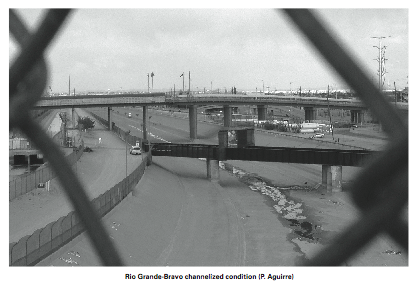
Water enables and constrains the way cities are designed and developed, and that which flows throughout the Rio Grande-Bravo has been the cause of numerous confrontations, not only between the US and Mexico, but also between states in both countries. But what if a common challenge—such as the supply, management, and conservation of water—could bring the cities of this region together? Indeed, the scale of and demand for water infrastructure necessitates a more integrated approach, especially as twenty-first-century cities are increasingly being challenged to perform more efficiently and act smarter in the way they invest in their resources.
It is fundamental to understand the issues of water systems in relationship to urban areas. Rapid urbanization across the border region, as well as high rates of industrialization, has exponentially increased the demand for water resources in a territory where the abundance of water is not necessarily a given. The population in the region has grown four times since the mid-1900s, currently at 12.5 million people, and is projected to double by 2050.2 With this expected population growth, cities need to change their consumer role and be more responsible with their use of water. What if ecological features such as watersheds were to begin to define regional management sites instead of political boundaries?


