Open Zoning Feed Specification (OZFS)
This ongoing work explores the possibility of an open-source and interoperable digital schema for decoding and encoding zoning data at the parcel level, building upon the precedent of the Open Mobility Foundation General Transit Feed Specification (GTFS) and Open Street Maps. The research advances zoning digitalization and information legibility focused on low-rise housing fabric as a mechanism to enable missing middle housing and small-scale urban infill by catalyzing development from the bottom up.
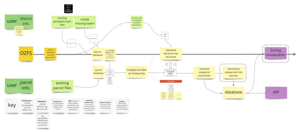
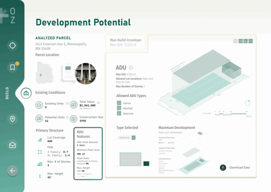
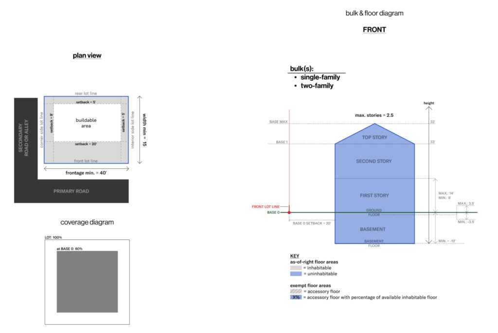
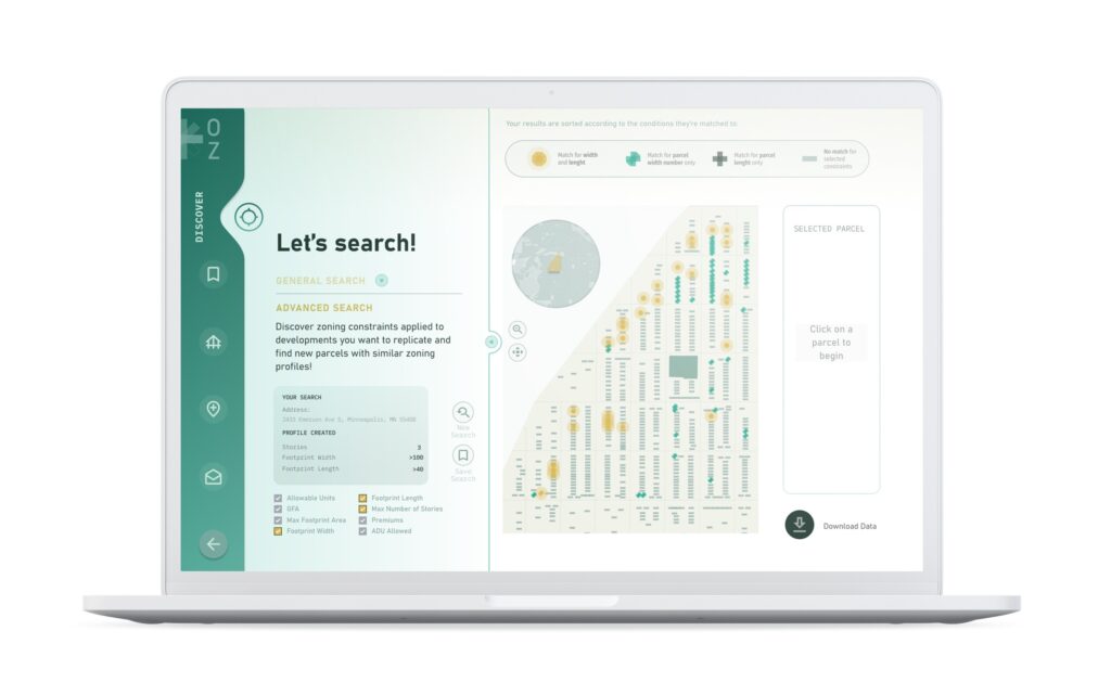
The Open Zoning Feed Specification (OZFS) research aims to democratize zoning codes, transforming them into legible, actionable development information for a non-expert audience by providing a data structure that can digitalize zoning data by encoding it into an open source and machine-readable format. The work involves the creation of a machine-readable zoning database that is assembled and structured through a feed specification (a data standard that anyone can use to contribute information). The open-source zoning data is made available to stakeholders in the form of an application programming interface (API) so that we and others can utilize the database to build web applications focused on enabling small-scale infill housing development. The data is structured to enable geospatial formats and highly accessible spatial visualization of zoning allowances at the parcel level.
The work is concerned with the growing housing shortage in the United States and the urgent need for mechanisms to increase the nation’s housing supply in urban areas. Zoning codes are critical infrastructure shaping our cities; however, their intricate legal language is challenging for small-scale builders, property owners, and housing advocates to decipher where and what they can build in their community. Despite great strides in zoning reform, a key remaining challenge is translating zoning policies into formats accessible to small-scale builders, property owners, and housing advocates to spark bottom-up action to combat our national housing shortage through the development of the numerous fine-grained infill parcels that are not attractive to large-scale development interests. Such development would both provide naturally occurring middle income housing and reduce VMT by increasing housing density in existing job-proximate neighborhoods. The work diverges from prior work on zoning code digitalization by creating an open-source data format that can easily be incorporated into software that automates the process of scanning a region to identify all parcels that have capacity for additional housing based on existing parcel geometries and zoning regulations.
Current work is focused on the refinement of a data schema to systematically structure the format and content of the feed specification. The research team is collaborating with cities and public agencies, local developers, and homeowners to refine data structure, collection method, and accessibility for a non-expert audience. Partnerships have included collaborative research with a Cornell Tech research team in 2023, ongoing collaborative research with University of Buffalo, and a case study with the Minneapolis Department of Planning. We are grateful for an ongoing dialog with Adrew Frey, Director of the Dept of Real Estate at the City of Miami, who has provided an invaluable and holistic perspective on real estate and policy.

Principal Investigators
- Elizabeth Bowie Christoforetti
- Carole Voulgaris
ViBE Lab Researchers
- Houpu Li
- Kamryn Mansfield
- Ana Merla
- Luke Reeve
- Paul Salama
2023 Cornell Tech Collaborators
- Michael Samuelian
- Paul Salama
- Nneka Sobers
2024 University of Buffalo Collaborator
- Lauren Fischer
Output
Christoforetti and Voulgaris. “Open Zoning Feed Specification.” 2024 American Planning Association National Conference, Spring 2024. Minneapolis, MN.